


Why Cabox?
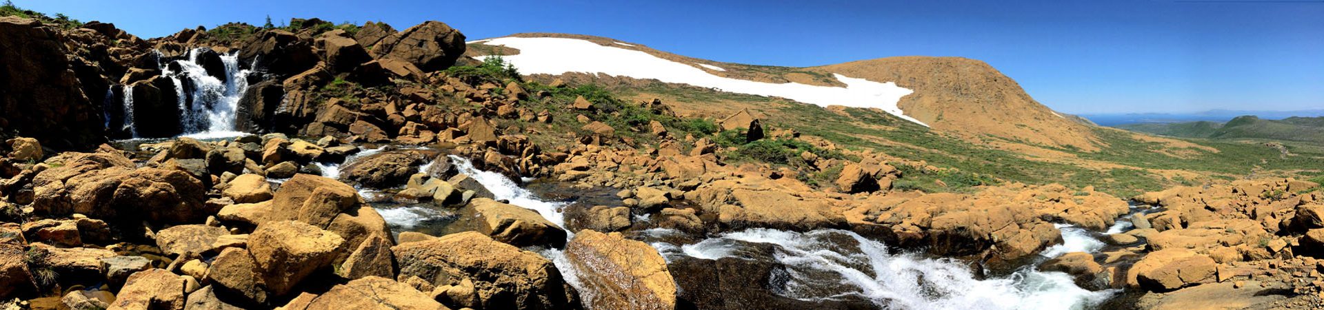
Cabox is the name of the highest peak on the island of Newfoundland and an Aspiring Global Geopark spanning the Bay of Islands Ophiolites, Transported Continental Margin and Ancient Continental Slope of the lower Humber Valley. It rises to 814 meters (2670ft) and is located on the Lewis Hills, the most southerly of the four Bay Of Islands Ophiolites, which also include the Blow Me Down Mountains, North Arms Hills and Tablelands, formed between the Upper Cambrian to Lower Ordovician geologic periods during the closing of the Iapetus Ocean and formation of the Appalachian-Caledonian Mountains.
The region is the core of the Humber Arm Allochthon and is often referred to as the Galapagos of Plate Tectonics for the role it played in confirming the theory of plate tectonics in the 1960s and 70s.

What Is A Geopark?
“UNESCO Global Geopark status is awarded to areas with geological sites and landscapes of international significance. The landscape is good for learning, while sites are rare and beautiful to view.
Since a UNESCO Global Geopark is a non-legislative designation, there is no associated land use restrictions, and no regional restrictions to recreational activities, prospecting and/or mineral exploration. It is a grass roots, community-driven initiative, providing a platform for increased tourism and regional economic development.”
Amanda McCallum
Ignite Education Inc.

Cabox Information Centre
Upon entering Saltbox, guests are greeted by a large interpretive panel describing the early exploits of renowned British surveyor and cartographer James Cook who explored the Bay of Islands in 1767 and later drew the most accurate outline to date of the region and island. He was followed by a series of prominent geologists who ‘colored in’ Cook’s maps with incredible details that helped confirm the scientific theory of plate tectonics in the 1960s, when most discussions about “rock” referred to earth shattering movements in music, not science.
On the opposite wall, visitors will find a large copy of Cook’s Chart of the West Coast of Newfoundland, published in 1768 while Cook was preparing for his first of three voyages to the Pacific Ocean. Below is a large panel describing the geology of Cook’s “Humber Arm” Allochthon and “Bay of Islands” Ophiolite Complex, which define the essential characteristics of Cabox Aspiring Geopark.


Of special interest to our American friends is a large colorful map of the entire Appalachian Mountain range from Georgia to Newfoundland. Compiled by renowned Newfoundland geologist Harold “Hank” Williams and published in 1978, the Tectonic Lithofacies Map of the Appalachian Orogen was the first map to show the full extent, origin and composition of the Appalachian Mountains and their relationship to the scientific theory of Plate Tectonics. Of special interest to local residents is the Ancient Continental Margin of Eastern North America, or “Humber Zone”, named after Western Newfoundland’s Humber Arm and Humber Valley, geographic center of the “Humber Arm Allochthon”.
Outside on the rear deck overlooking scenic Humber Arm, a large commemorative panel dedicated to Williams describes his geological accomplishments, including his 1964 paper entitled “The Appalachians in Northeastern Newfoundland – a Two-Sided Symmetrical System” and his 1967 geological map of Newfoundland, two of the keystones in the concept of an opening and closing proto-Atlantic Iapetus Ocean which helped confirm the theory of plate tectonics.
Next to the Williams panel is a modern Geological Map of Newfoundland produced by the Geological Survey of Newfoundland and Labrador which shows in a myriad of brilliant colors the geological diversity of the island at the center of the Appalachian-Caledonian Orogeny, which stretches from the southeastern United States to Eastern Canada, then across the Atlantic Ocean to Greenland, the British Isles and Norway.
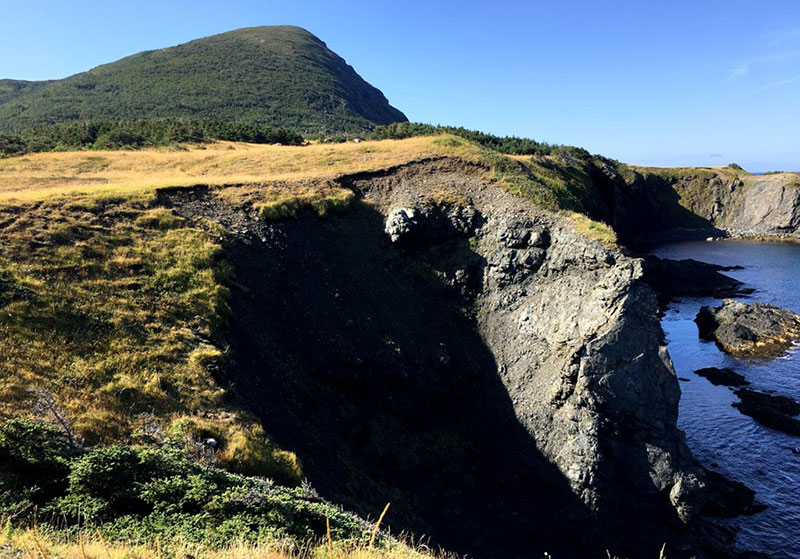
The rear deck also displays a series of large panoramic photos representative of Cabox Aspiring Geopark, as does the interior dining room. Two monitors also present a slideshow of Geopark vistas, maps, and heritage themes meant to educate and inspire local residents and visitors to the region. A large floor to ceiling 3D-shaded topographical map provides a complete overview of the Geopark, from mountains and valleys to trail routes, coastlines and zodiac tours. Take all the time you need to explore, and enjoy a delicious meal, ocean view and ice cold beer!
For more information on the Cabox Aspiring Geopark visit www.caboxgeopark.org

Cabox Cabin Rental
The IATNL/Cabox Geopark Basecamp at Stowbridges Cove, North Arm, is a restored 2-storey biscuit-box-style summer fishing house located at the base of the North Arm Hills on the north shore of the Bay of Islands. It is strategically located (and available to rent) at the southern end of the IATNL North Arm Traverse and Stage Two of the IATNL/Cabox UltramaTrex.
Contact us for more information about booking the cabin!
